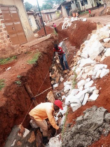
Nabweru Town Council Moves to Fix Drainage System
Submitted by wakaija on

Nabweru Town Council has embarked on its development projects through constructing roads and water trenches as a measure to minimize the problem of floods in the area of Kazo.
Kazo, located in Nabweru Division, Nansana Municipality, Wakiso District, has witnessed heavy rains that caused floods from the start of September. Rains put the lives of some of Nabweru residents at stake as they leave them homeless and desperate.
The zone includes Kazo Ward, Kazo West, Kazo South and Kazo Muganzirwazza. However, Kazo South and Kafunda trading centre are the most affected areas.
“Construction of Kafunda Road and water trenches will stop water from entering shops and people houses,” Mzee Mukasa, Chairman LC1, Kazo Muganzirwaza explained.
According to a September report from the Uganda Meteorological Authority, “September to December constitutes the second major rainfall season over most parts of Uganda.”
The September rains left many residents of Kafunda and Kazo South homeless and traders registered big losses. An electronic shop on Ssendagire Building in Kafunda was flooded and electronics like Television, radio woofers worth 10 million shillings were damaged.
On October 1, a community meeting was held at Kazo Primary School to discuss issues of people's welfare. Chairman Mukasa said: “We are going to demonstrate until the problem of floods gets off people's mouths. We call upon authority to respond positively to this outcry, we shall not sit see our people dying.”
One of the victims of the rains was an elderly woman only identified as Naggawa, aged 85, who was found in her small house unconscious in a pool of water following a heavy down pour. Several other meetings were organised in the town council to find a solution floods.
The town council has embarked on road construction and unblocking of culverts that had been covered by solid waste and polythene bags brought by running water.
Initially, Kazo Zone was a swampy and a water catchment area however, it started drying up as people encroached on it and built houses.
During a community meeting at Kazo primary school, Nabyonga Esther, a health officer warned that residents were at risk of cholera outbreak and other diseases caused by poor hygiene.
Geographically, Kazo Muganzirwazza is at a high altitude than Kazo South, running water flows from Muganzirwazza pouring into Kazo South.
- 949 reads
